A few months back in colder weather!
Now that the lock-down is slowly being eased in Italy, I’ve managed to slowly get back to running outdoors. I’ve tried the treadmill, but it’s nowhere like the same level of freedom. There’s one route — roughly 5k — that I love particularly, which gives the chance to run right through the very heart of ancient Rome.
In these strange times we live (and not only), running is for me a source of sanity. Thankfully, running is also great for social distancing. The vast majority of runners I see love running alone, and I guess most (like me), want to run alone. If you know your times and places you can avoid the crowds, and especially as summer slowly draws close Rome is loveliest for running early in the morning — it’s light by 6am, and still nice and fresh. Anything past 8am gets busy and warm.
The 5k route
My route starts at Trajan’s column, proceeds along via dei Fori Imperiali, round the Colosseum, then via di San Gregorio, makes a loop in the Parco di Porta Capena, proceeds along the Circo Massimo, makes a detour into the Velabrum area, and then onward to finish at Piazza Venezia close to the starting point, a total of around 5k. I will divide the route into five sections of around 1k each, and describe some variants at the end.
route on Google Maps / alternatively on Garmin
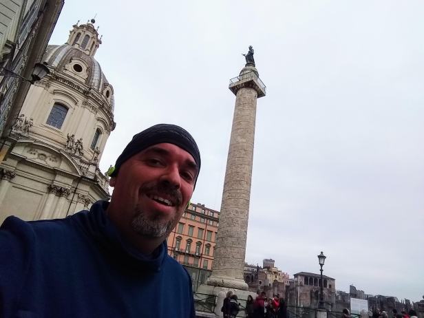
Trajan’s column to the Colloseum
I generally start my run at Trajan’s column, right behind Palazzo Valentini. (The Domus Romanae [external link] here are really worth a visit). The little piazza here offers also a good space for stretching and warm-up.
The huge white monument to Vittorio Emmauele II, with the tomb of the unknown soldier, is a landmark you cannot miss, and marks the beginning of Via dei Fori Imperiali. It’s not my favourite monument in Rome, and judging by the nicknames it gets — the “Wedding Cake” or “Mussolini’s Typewriter”, I’m not alone. The first part of the run is along via dei Fori Imperiali, with its wide pavements (that’s sidewalks to the US American reader!). I tend to prefer the western side – that’s right-hand side heading to the Colosseum, which is (usually) less crowded.
On the western (right-hand) side, you have a better look at the Forum of Caesar and the Roman Forum with their monuments. On the eastern (left-hand) side, a better view of the imperial fora – first Trajan’s with the monumental column and the large semi-circular market that dominates above you (and interesting Museo dei Fori Imperiali [external link]), then the Forum of Augustus, and finally that of Vespasian with its Colonacce.
Past the junction and traffic lights, dominated by the Torre dei Conti, you proceed in a narrower part of the road, with the Basilica of Saints Cosmas and Damian, and the ruins of the Basilica of Maxentius. The pavement here is narrower, and has a high metal railing. I generally prefer running on the road itself, and I see that most runners do the same. It is far easier to avoid bumping into pedestrians when it gets busy, and makes it easier to keep social distancing. Hardly any traffic passes here, and the bus drivers and police/army cars are clearly used to the runners — but do keep your eyes and ears open for cars, just in case.
Getting to the Colosseum, my run goes around the monument, staying close to it. Here you should be around the 1k mark, depending on where you actually started. Do make sure to keep close the monument itself, where the paving is in sanpetrini (the small basalt stones). Further out there is a section of ancient Roman road in basolato which is treacherous to run on.
Colosseum to Porta Capena
Once around the Colosseum, the Arch of Constantine is right ahead. Here turn left onto via di San Gregorio, which runs between the Palatine hill (on your right) and the Celium hill (on your left). The aqueduct that crosses the road is the Acqua Claudia that supplied the Palatine, and its sprawling imperial palace and baths.
For the first short stretch, close to the Arch of Constantine, it is possible to run on earth/soil — a welcome break from pounding the hard basalt. I then keep running on the right-hand pavement until the pedestrian crossing, where I shift to the left-hand side.
Passing by the Basilica of San Gregorio al Celio (on the upper street), turn left unto Piazza di Porta Capena, and then toward the via di Valle delle Camene. You should be around the 2k mark.
Parco di Porta Capena
Porta Capena, which gives the name to this piazza and parco was one of the city gates in the ancient Servian Walls. The gate was removed at the time of Caracalla, and only some remains were excavated in 1867.
The run here can take different options. One is the side road (via di Valle delle Camene), which is very quiet and popular with runners, to the extent of having distances marked on the ground. There are also two paths in the narrow park, known for its shape as il Biscotto (the biscuit), one on the inner side, closer to the side road, another on the outer side closer to the Viale delle Terme di Caracalla. This little part also has an outdoor gym of sorts, and a water fountain, which can be a welcome spot to drink.
The park itself is between the Celium hill and the Aventine hill, dominated by the huge ruins of the Terme di Caracalla. Within the park itself is the small rudere di Porta Capena, and the deconsecrated chapel of Santa Maria in Tempulo, which incorporates ancient Roman remains.
The loop in this park, depending on the options, is around 1km. Of course, those preferring a shorter route, could simply skip this section, and keeping running on the right hand side in via di San Gregorio, turning immediately left to the Circus Maximus.
Once at the end of the Parco di Porta Capena, cross carefully onto the central strip, towards the main junction (with traffic lights and pedestrian crossing). Make sure to cross safely towards the Circus Maximus, and the beginning of Via dei Cerchi. Once here you will also need to find a safe place to cross the street (which is busy at intervals) to be on the side of the Circus Maximus itself.
Circo Massimo to Velabro
The Circo Massimo (Circus Maximus) was the hippodrome of Rome, and greatest horse race venue in the whole empire. What survives is its mere shadow, nestled between the Palatine hill which overlooks it from the north east, and the smaller Aventine hill (piccolo Aventino) on the south west. At the southeastern end, towards the beginning of via dei Cerchi is are ruins of the semi-circular end of the hippodrome.
Right after the first part of the pavement, you can move onto softer ground running on the upper rim of the hippodrome, and proceed northwest along the edge of the Circus. All along the route are the majestic remains of the Palatine Hill on the right, and in the final stretch a row of shops still within Roman and medieval remains.
Once you reach the end of the Circus, aim for the pedestrian crossing and lights, cross the via dei Cerchi heading into via di San Teodoro and the Velabrum (Velabro).
The Velabrum onto piazza Venezia
The Velabrum, the valley between the Palatine and Capitoline hills, is quite tucked away, and off the usual tourist routes. At the beginning of via di San Teodoro, coming from the Circo Massimi, the piazza di Sant’Anastasia opens quite unexpectedly to the right, fronted by the Basilica of Saint Anastasia, and a having a welcome water fountain.
Running past the farmers market on the left (open Friday-Saturday-Sunday), the first alley to the left — which I run past — leads to the Basilica of San Giorgio in Velabro, and the arch of Janus. Further along the route, to the right is the Orthodox Church of Saint Theodoros, within the ruins at the foot of the Palatine. All along the road you keep the ruins of the Palatine hill to the right.
The road obliges you to take a left turn at the end of the road, right past the Belgian embassy, along via del Foro Romano — with a view on the Roman Forum, and then left again onto the via della Consolazione. Here the choice is to head up, past the police booth onto the Capitoline Hill (see variant A below), or down towards Piazza della Consolazione. I tend to cross the small square here, and run on the pavement to the right heading down.
Its downhill first past the piazza with the Rupe Tarpea on your right, and down via del Jugario. There’s a water fountain as you head down if you’re thirsty. To the left of the road is the Church of Saint Ombono, and the remains of the area Sacra di Sant’Ombono.
Once on the main road, turn immediately left. Keeping on the right hand pavement, at the foot of the Capitoline Hill, the run proceeds uphill on Via del Teatro di Marcello. Across the road, on the opposite side, is the Church of San Nicolo in Carcere which incorporates elements of two Roman temples. Further along the road, always to your left, you can see the Teatro di Marcello which over the centuries was transformed into a stronghold of various noble family, notably the Savelli and the Orsini. The three lonely columns forming a corner are what remains of the Temple of Apollo Medicus Sosianus.
Once on the brow of the road, you meet to your right the beginning of the picturesque staircase up towards the Campidoglio and the Palazzo Senatorio, and then the breakneck staircase leading to the Basilica di Santa Maria in Aracoeli.
Keeping along the right side, you also see the ancient Roman Insula di Aracoeli with the incorporated medieval ruins, dominated by the white structure of the monument to Vittorio Emmanuele II. Across the piazza (with the bus terminus) is the Basilica of San Marco and the side of Palazzo San Marco. You should hit the 5k mark before you reach the front of the monument to Vittorio Emmanuele II.
Variant
A. Up the Capitoline Hill
If in the mood for an uphill run (and fit for it!), at the small square behind San Maria della Consolazione, head past the police booth, and up via Monte Tarpeo. You will meet a great viewing point onto the Roman Forum, the back of Palazzo Senatorio (the base of which is the ancient Tabularium), the Velabrum, and the Palatine hill.
Take a sharp bend left, and continue uphill (!) on via Monte Tarpeo then right on via del Tempio di Giove. At the top of the hill, across the road, a large window (a metal grate) gives you a glimpse of the ruins of the Temple of Giove Capitolino, now within the Capotoline Museums [external link]. There’s a drinking fountain in this little piazza.
Proceed then left on via del Tempio di Giove, and follow the road right on Via di Villa Cafarelli and Via delle Tre Pile. At the end of this road pass through the large stone arch onto Piazza del Campidoglio. This iconic square was re-designed by Michelangelo, and fronted by the Palazzo Senatorio, and flanked by the Palazzo dei Conservatori and Palazzo Nuovo. The square is dominated by an equestrian statue of Marcus Aurelius (this is now a copy, the original being inside the Musei Capitolini).
Head diagonally across the square, and then downhill past on via di San Pietro in Carcere, right to the beginning of via dei Fori Imperiali close to where the run started, totalling slightly in excess of 5k.
B. Shorter variants
The route offers slightly shorter options too. One option, indicated earlier, which makes it 1k shorter, is to eliminate the loop on Parco di Porta Capena heading directly from via di San Gregorio right onto via dei Cerchi.
A second option to shorten the route is to cut out the deviation into the Velabrum. At the end of the Circo Massimo instead of heading into via di San Teodoro keep straight on via dei Cerchi towards via Luigi Petroselli and onwards to via del Teatro di Marcello and Piazza Venezia.

Hello, dearest Josef!
For the last 3 weeks, I have been walking (briskly) for an hour every day.
Of course, nothing as splended and interesting as yours, but at least, I am keeping my promise never to let a day pass without some exercise. I had a medical warning earlier on in May and one of the things I am changing in m life is precisely that: exercise.
Nice to note the beautiful route that you’re taking – wow! Keep at it and remember your good luck to be in such a beautiful city.
Take care.fc